
Student Volunteers at SHA Québec 2014
 Student volunteers are essential to the smooth operation of an SHA Conference. By assisting with a variety of duties – from registration and Book Room set-up to special events and the sessions themselves– volunteers are a key component of the Conference’s smooth operation.
The SHA is looking for student volunteers to give minimally 8 hours of their time during the SHA Conference in exchange for free conference registration. If you are a student and would like to volunteer your time in exchange for the opportunity to attend the SHA 2014 Conference at no charge, complete the information and the volunteer schedule hosted at http://www.sha2014.com/volunteers.html and return both to Conferium (the address is on the form). You will be reimbursed for the amount of your basic registration rate IF you are accepted as a volunteer. Please note you must pre-register for the conference at the appropriate student rate and also register for any workshops, tours, Roundtable luncheons, the reception at the Musée de l’Amérique francophone or the Awards Banquet wish to attend.
Applications will be accepted according to organizational needs on a first-come/first-served basis until December 6, 2013. Although priority will be given to bilingual speakers (English and French), all are welcome.
Les étudiants bénévoles sont essentiels au bon déroulement des colloques de la SHA. En participant à une variété de tâches – de l’enregistrement des congressistes à la mise en place du « Book Room », en passant par le suivi des sessions elles-mêmes – les bénévoles participent au bon déroulement de toutes les activités organisées dans le cadre du colloque.
Le comité organisateur de la SHA est à la recherche d’étudiants prêts à donner bénévolement un minimum de 8 heures de leur temps durant le colloque en échange de leur inscription gratuite. Si vous êtes un étudiant et que cela vous intéresse, vous n’avez qu’à compléter le formulaire, ainsi que l’horaire figurant au verso, que vous trouverez à l’adresse http://www.sha2014.com/volunteers_fr.html et à retourner le tout à Conférium à l’adresse indiquée sur le formulaire. Nous vous rembourserons du montant des frais d’inscription de base si votre candidature est retenue. Vous devez vous inscrire au colloque et à toute autre activité –atelier, visite guidée, dîner table-ronde, la réception au Musée de l’Amérique francophone, le banquet d’honneur, etc. – si vous souhaitez y participer.
Les candidatures seront retenues selon les besoins organisationnels et selon le principe du « premier arrivé, premier servi » jusqu’au 6 décembre 2013. Même si tous sont les bienvenus, la priorité sera accordée aux personnes bilingues (français et anglais).
Understanding Cemeteries through Technical Applications: An example from Fort Drum, NY

A few times each year, the SHA Technology Committee hosts Tech Week, an entire week devoted to certain technologies used in historical archaeology. This week, archaeologist Duane Quates was asked to gather blog posts about the use of technology in mortuary analysis.
Fort Drum, New York has a surprisingly rich history and the 13 historic cemeteries of Fort Drum are a profound reminder of the communities that existed prior to the Army’s acquisition of the now 107,000 acre military reservation in 1941. Current technologies such as LiDAR, GIS, database management software, and geophysical technologies, such as ground penetrating radar, magnetometry, and electrical soil resistivity are providing the base archaeologists with innovative tools to understand and mange these resources responsibly.

Figure 1: The grave of William Anderson and his wife Elizabeth
One of the many aspects of the cemeteries that I found interesting is that there are only two known African American gravestones out of 1802 known burials. One grave is that of William Anderson and his wife Elizabeth located in the Gates Cemetery near Historic Sterlingville. The second is that of Rachel, a former slave of James Leray, in the Sheepfold Cemetery. The graves in both of these cemeteries are very similar in that they are alone in the back of the cemetery, segregated from the rest of the burials.
Unfortunately the archaeological record of the base is very similar in its representation of the African American community. To date, the Cultural Resources Program at Fort Drum has identified 962 sites on the 107,000 acre military reservation. Over 65% of the recorded sites are historic. However, only two known sites are considered to have an African American component; the LeRay Mansion Slave Quarters and the Whitney Farmstead. The first is associated with James LeRay de Chaumont, a French capitalist and land speculator, whose family fortune was acquired largely from the transatlantic slave trade. The second is associated with a 19th century farmstead that, unfortunately, is poorly understood. This assemblage includes trade beads from Gambia, West Africa, as well as Lamoka points from the late Archaic Period.
The Fort Drum Cultural Resources Program manages and maintains the cemeteries of the post. Rachel’s marker is one that has given us the most concern. It is made of a poor quality marble that has frost fractured several times. Each time the Fort Drum Cultural Resources Program has repaired it with epoxy but unfortunately time and weather has taken its toll on the stone. The epitaph is no longer fully legible.

Figure 2: The grave of Rachel
In April 2010 at the Society for American Archaeology meeting in Sacramento, CA, while perusing the book room, I met Bill Mongon of Accurex, Inc. in the technology section of the book room. He was demonstrating a multi-lens camera that was capable of building a 3D model of almost any object. What I found fascinating was the system’s capability of finding minute details on objects that were not detectable by the naked eye. I asked if there were any field applications for the device. Bill suggested that he travel to Fort Drum and provide a demonstration by scanning Rachel’s grave stone. The demonstration at Rachel’s grave site went beautifully. The system performed perfectly in spite of a continual rain that drenched us. Fortunately, scanning Rachel’s grave stone took only 2 hours.

Figure 3: 3D scan of Rachel’s grave stone
In figure 3 the epitaph is very clear, which reads: “Rachel A good & faithful nurse. Died Jan. 10 1834.” The lower epitaph reads “This monument was placed in her memory by her loving children Vincent & Alexander LeRay de Chaumont & Therese de Gouvello.” Ironically, one year after this scan was done, while giving a tour of the cemetery I found the grave stone broken into several pieces by a large oak tree that had come down in a wind storm. Fortunately, we have the 3D scan of the stone allowing us to replicate it.
In 2010, the Cultural Resources Program at Fort Drum embarked on a new project to answer several pressing concerns about the cemeteries. First, we suspected that there were unmarked graves surrounding the two known African American grave markers. Military training had the potential to encroach upon the boundaries of the Sheepfold Cemetery where Rachel lies, with the new development and expansion of nearby training course. It was necessary to know, with absolute certainty, whether the boundary of the cemetery was accurate or if there were burials outside of the fence. Second, we also wanted to make a concerted effort to find whether there were other African American graves in the other cemeteries on the base.
To answer these questions, an inventory of our cemeteries was necessary and then the attributes could be compared. Once that was completed and the African American graves identified, geophysical surveys would be conducted in the vivinity. Unfortunately, the staff did not have the expertise or training needed to perform the geophysical surveys. Fortunately, I was able to acquire funding to hire an intern, Mike Sprowles, through the Oak Ridge Institute of Science and Education (ORISE) to complete the project.
Mike started the project by creating a database and developing the attributes that he intended to record. The database became something more than what was originally intended. His database can compare attributes of all 1802 burials and search for similarities. It also has the capability of tracking the conditions of each stone and is a perfect tool to manage the cemeteries. Finally, it is searchable by name and can be used by any member of the public for genealogical research. He finished the inventory in just 10 months and we publicly launched the database as a genealogy tool in October of 2012. He has surveyed both the Gates cemetery and the Sheepfold cemetery and found several anomalies consistent with unmarked burials near Rachel’s grave stone.
But I digress. I will let Mike explain this project in his own words in his blog post. Also, the Tech Week Blog will feature Dr. Michael Heilen of Statistical Research Inc., discussing the Alameda-Stone Cemetery in Tucson, AZ, as well as Katy Meyers, PhD. Candidate at Michigan State University, with her post on the spatial analysis of the Mount Pleasant Cemetery in Livingston County, New York. These posts have several things in common. All discuss the use of GIS and databases in their analyses. However, each is unique in how they demonstrate the advantages of these technologies in cemetery studies. The thing that excites me about archaeology’s use of technology is the surprising results one gets when applying various techniques to a particular problem. Technology has a way of finding answers to questions that you never intended to ask.
Read the First Post in this week’s Tech Week: “Examining Space of a Resting Place: GIS of a New York Cemetery” by Katy Meyers.
Examining Space of a Resting Place: GIS of a New York Cemetery
This post is part of Tech Week, which highlights a group of posts about specific applications of technology to archaeological investigations. This week, the focus is on Technology and Mortuary Archaeology. See the other posts in this series here.
“Will you be buried or will you be cremated? I think I’d like to be buried so I have a headstone like Elvis. Though I think that when you have a headstone and you’re in a place it puts great pressure on your family, your surviving family, to visit you.”
-Rob Brydon, The Trip
Place is important. As Brydon says in the movie “The Trip”, place allows you to create a mark and leave something tangible behind in your memory, but it also puts a responsibility upon the mourning community. Place gives us a sense of belonging, a heritage and ancestry, and a deeper connection to our surroundings. Burials are the final statement of place that humans get to make- for themselves through wills, for their loved ones, or even for their enemies in battle. Both the manner of the burial, memorial and the place are important.
The memorials of the deceased reflect the historical present in which they were buried. Grave markers, location of burial and epitaphs all follow trends that help us better interpret what was of social importance during these periods. Due to the high emotion of death, the trends associated with burial are usually slow to change and have high social significance. Examining the patterns of grave markers and epitaphs aids in creating more nuanced interpretations of how individuals wanted to memorialize and remember their relatives, and also how these patterns changed through time. As Cannon (2002:191) argues: “the growth and transformation of these expressions over time can therefore be read as a historical narrative of individual choices made in response to spatial representations of the immediate past and perceptions of current and anticipated social and political circumstances”.
A geographic information system (GIS) is a computer based program that allows us create spatial maps in order to visualize, analyze, and interpret data to reveal patterns. Spatial data (data with longitude and latitude, or other geographic coordinates) is given attribute data (any information about the spatial points such as type of grave marker, date of death, name of individual buried within), and is input into GIS. The program has a number of statistical and spatial tools that allow us to analyze the spatial patterns of the associated attributes. An example would be examining whether individuals near to one another were died in similar years. By using GIS, we can better analyze historic cemeteries to understand the importance of place in both the deceased and mourning communities.

The Mount Pleasant Cemetery is approximately an acre in size, and located off Interstate 390 and Route 20A in Livingston County, New York (Figure 1). It is one of ten cemeteries registered to the town of Geneseo, a small farming community established in 1790. The Mount Pleasant Cemetery was established in the early 1800’s by the Kelly Family, and was the first cemetery for Presbyterians in the area. The original date of origin is unknown, though newspaper clippings from the 1850’s note that it was already well established by then. From an outsider perspective, the cemetery appears to have a random organization, lacking distinct rows and coordinated orientations to cardinal directions. In order to better interpret one of the early cemeteries of this small New York community, GIS was employed.
Each grave marker was spatially located using GPS, and attribute data was taken. Stones were first given a ranking of primary through quaternary. It was immediately apparent upon collecting the data that stones fell into a number of categories based on ancestry. Most of the plots within the cemetery were small and consisted of one large grave marker with the family name, and then a number of secondary, tertiary and quaternary stones in increasing distance from the primary marker. The primary stone included the main family stone only, usually found at the center of the plot with the patriarch’s name and death date highlighted, and other family members listed below. Secondary markers were smaller and usually lacked personal names, instead noting only familial relationship to the patriarch. Tertiary and quaternary markers were often different in style, material, and contained more information such as name and death date. Style of grave marker was also noted, and included obelisk, column, mausoleum, pulpit, tablet and flush. Family name, epitaph and death date were also recorded. In total, 34 family plots and 265 grave markers were mapped and assigned attribute data on ranking, style, and dates (Figure 2).
 The presence of these large family memorials and lack of personal names reveals the high importance of family. Due to this, the analysis using GIS was employed to determine whether distance to the family marker correlated to dates or relationship, and whether space within each plot had specific organization. Both nearest neighbor and Moran’s I was employed. Neither revealed any strong correlation between the rank of the stone, relationship of the person and distance to the primary family marker. Instead, the stone appear to have more random distribution within the family plot. This, however, does seem to be a common characteristic of this era and style of cemetery. As Mytum (2004:126) writes, “such memorials usually have no individual epitaphs or descriptors of any kind, and it would seem that after death all that mattered was familial association”. Other GIS studies such as Hoogendoorn 2007 found similar results, with stone organization being due to family relationship.
However, an analysis purely of style revealed that there were areas in the cemetery where specific styles of family markers were more popular than others. Further examination revealed this was related to date and shows the growth of the cemetery and change in the fashion trend. However, this correlation works for only the earliest date. The cemetery continues to be used, and families have maintained their connections with their 19th century ancestors. These newer stones, usually quaternary, have the names of the individual and their death date written on them rather than simply being noted on the family marker like the secondary or tertiary markers.
Place is important throughout our lives, and our final burial location is indicative of this importance. GIS is a powerful tool to allow us to find patterns and from these make interpretations of why communities chose to bury their loved ones in specific arrangements. It is interesting to watch this landscape change as we become more mobile, and people are less tied to their ancestral lands. It seems now that the place we find important, and one that may be our lasting memorial is more digital, such as Facebook pages for the deceased… but this is a conversation for another post.
Read the Second Post in Tech Week: “Application of Advanced Technologies in Excavation, Analysis, Consultation, and Reburial: The Alameda-Stone Cemetery in Tucson Arizona” by Michael Heilen
Works Cited
Cannon, Aubrey
2002 “Spatial Narratives of Death, Memory and Transcendence” in Archeological Papers of the American Anthropological Association 11(1) Jan. 2002: 191-199.
Hoogendoorn, Arie, Jeffrey C. Brunskill, PhD and Sandra Kehoe-Forutan
2007 “A Study of Spatial and Temporal Anomolies Associated with the Placement of Gravestones at McHenry Cemetery in Orangeville, Pennsylvania”. Poster presented at Middle States Division of the Association of American Geographers, Pennsylvania, November 2007.
Mytum, Harold
2004 Mortuary Monuments and Burial Grounds of the Historic Period. Kluwer Academic/Plenum Publishers, New York.
Application of Advanced Technologies in Excavation, Analysis, Consultation, and Reburial: The Alameda-Stone Cemetery in Tucson, Arizona
This post is part of Tech Week, which highlights a group of posts about specific applications of technology to archaeological investigations. This week, the focus is on Technology and Mortuary Archaeology. See the other posts in this series here.
In recent years, the technologies that have affected most how archaeologists do their work are digital and computing technologies. These technologies can greatly improve the accuracy, precision, and efficiency of archaeology as well as enhance our ability to analyze, share, and curate the data we generate. Of these tools, some of the most useful have been relational databases, geographic information systems, visualization tools, and digital mapping instruments, such as global positioning systems, total stations, and lidar.
A few years ago, I had the opportunity to participate in a large, highly complex, and community-sensitive excavation project in downtown Tucson, Arizona. The project was very important to Pima County—the project sponsor—the city of Tucson, and to multiple descendant communities. The project site was the location of the long-abandoned Alameda-Stone cemetery, a cemetery used by residents of the Village of Tucson beginning in the late 1850s or early 1860s. Divided into several sections, the civilian sections were closed to further burial in 1875, while the military section was closed in 1881. The 1,800 to 2,100 people buried in the cemetery were of diverse cultural and religious backgrounds, including individuals of Hispanic Catholic, Euroamerican Protestant, Jewish, Tohono O’odham, Yaqui, and Apache backgrounds, as well as military personnel.
After the cemetery was closed, a few hundred burials were moved to new cemeteries, but most were left in the ground. As Tucson urbanized and grew, buildings, streets, and utilities were built throughout the cemetery and all visible reminders of the cemetery were erased. Despite these disturbances, many of the burials remained intact when the cemetery was professionally excavated by Statistical Research, Inc. in 2006-2008.
To comply with legal requirements, including burial agreements for the cemetery excavation, all human remains and burial-associated objects within the 4.3 acre project area had to be recovered. The discovery of burials had to be reported daily and the location and status of all recovered items and materials had to be tracked throughout the duration of the project. Due to the large number of descendant groups who could claim remains from the cemetery, the cultural affinity of human remains and burial associated objects had to be established as firmly as possible using multiple lines of archival, contextual, and osteological evidence. Moreover, the project needed to be completed from beginning to end within a period of just four years. Most projects of this size are performed over a substantially longer time frame.
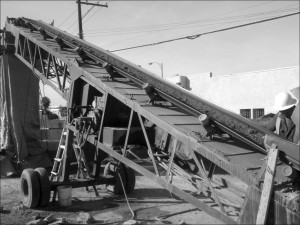
Figure 1. Use of a TEREX Powerscreen Mark II to recover artifacts and osteological materials from the project area overburden (image courtesy of SRI Press and Left Coast Press).
A variety of new technologies were used to accomplish these goals. Since all human remains had to be recovered, screening of the massive volume of cultural deposits, including overburden, was necessary (Figure 1). Burial features were excavated by hand, but fragmentary remains were also present in secondary contexts in areas of the cemetery where burials had been disturbed. The recovery of these materials was accomplished using construction equipment and an automated screening machine. These tools required an operator to run and maintain, but their use greatly sped up the search effort and enabled all cultural deposits to be thoroughly screened.
To glean as much information as possible from exposed burials, burials were intensively documented in situ using photogrammetry and three-dimensional laser scanning, in addition to more traditional mapping techniques (Figure 2). Maps of burial features were then created in a geospatial laboratory using point-provenienced spatial data, orthorectified digital photos, 3-D scanning data, and analysis data. Recovered artifacts were stored and analyzed onsite and bagged using printed, bar-coded labels that allowed all recovered materials to be accurately provenienced and tracked throughout the project.

Figure 2. Illustration of the mapping process for Grave 13614, Burial 21829, an adult Euroamerican male (courtesy of SRI Press and Left Coast Press)
Excavation resulted in the intensive investigation of more than 1000 burial features and the recovery of the remains of more than 1300 individuals, making this one of the largest excavations of a historical-period cemetery conducted in the United States. Excavation also documented several prehistoric features predating the cemetery and more than 700 post-cemetery features, including building foundations, privy pits, utility trenches, and landscaping features. Use of the above technologies decreased field time considerably, making better use of field labor and allowing greater attention to be focused on analysis, reporting, and consultation efforts.
All the resulting data collected in the field and laboratory were stored in a sophisticated relational database system. The system allowed analysts to query and manipulate massive volumes of data in a flexible and consistent manner in support of diverse analyses and to differentiate remains according to cultural affinity, as required by the project burial agreement. In addition, the system provided a platform for tracking all the project materials from the moment they were discovered in the field until they were reburied or repatriated. As the project came to a close, the remains of more than 1300 individuals were repatriated or reburied. Advanced technologies continued to play a role in facilitating this stage of the project by ensuring that remains were repatriated and reburied correctly according to the wishes of descendant groups.
Of course, use of advanced technologies is not an alternative to solid, traditional research or careful project management. Much consideration and effort is needed to ensure that technologies are used appropriately and effectively. Many of the technologies implemented during the project require monetary investment to purchase or lease and, to implement them successfully, training or hiring of staff with specialized skills. Substantial computing resources are needed—including servers, networks, and software—and these have to be built, operated, and managed by skilled professionals. Archaeologists and other staff working on the project had to learn collectively how to make these technologies work together to answer research questions and fulfill project requirements. The project database and geographic information system had to be coordinated and continuously tested to make sure these systems were operating properly and analysts were working with the correct and most up-to-date data.
It was also important to ensure that the use of a technology did not take on a life of its own. Technologies are only useful insofar as they fulfill a need. Project leaders had to continually question how and whether a technology was successful in meeting a need of the project and to consider what could be done to improve performance. For a project of this size, which had as many as 70 people in the field at any one time and employed upwards of 150 people of diverse backgrounds and positions, project leaders had to manage positions as much as they managed people. People came and went over the course of the project, but the position they occupied always needed to be filled. Similarly, many computers, servers, and instruments were used over the course of the project. Some components failed or needed periodic maintenance, but the technology always had to be managed, monitored, and properly maintained.
Finally, many of the technologies used in archaeology today were not designed specifically to address archaeological problems. Substantial effort and planning can be needed to adapt technologies to archaeological needs and to develop systems and protocols for their use in an archaeological context. The unique requirements of the excavation project provided the rationale and funding for a large investment in advanced technologies, particularly those involved in mapping and database systems. Other projects could likely benefit from similar technologies but may not have the staffing or funding to invest in or manage them. What can the discipline do to foster the wider application of technology to archaeological problems and to promote broader access? Further, what are the most effective ways for archaeologists to share information on where technologies succeed, where they fail, and how they can be improved?
Read the final Tech Week piece “Mortuary Analytics on US Army Garrison, Fort Drum, NY” by Michael Sprowles
Further Reading:
Heilen, Michael P. (editor)
2012 Uncovering Identity in Mortuary Analysis: Community-Sensitive Methods for Identifying Group Affiliation in Historical-Period Cemeteries. SRI Press, Tucson, Arizona and Left Coast Press, Walnut Creek, California.
Mortuary Analytics on US Army Garrison, Fort Drum, NY
This post is part of Tech Week, which highlights a group of posts about specific applications of technology to archaeological investigations. This week, the focus is on Technology and Mortuary Archaeology. See the other posts in this series here.
Hundreds, if not thousands, of cemeteries can be found on numerous military bases across the county. Many date back to early towns and villages and hold the graves of early settlers and later, military personnel. The 13 historic cemeteries (2,100 markers) of US Army Garrison Fort Drum, New York are no different. (Fort Drum is located just east of Lake Ontario, and is the 107,000+ acre home of the US Army’s most deployed Division, the 10th Mountain Light Infantry.) Through the Directorate of Public Works (DPW), the Army works to maintain these cemeteries and to minimize military impact to these sites. Although on Fort Drum these responsibilities are carried out by the Cultural Resources Program (CRP) of DPW – Environmental Division, the process of stewardship can and does differ widely from one post to another.
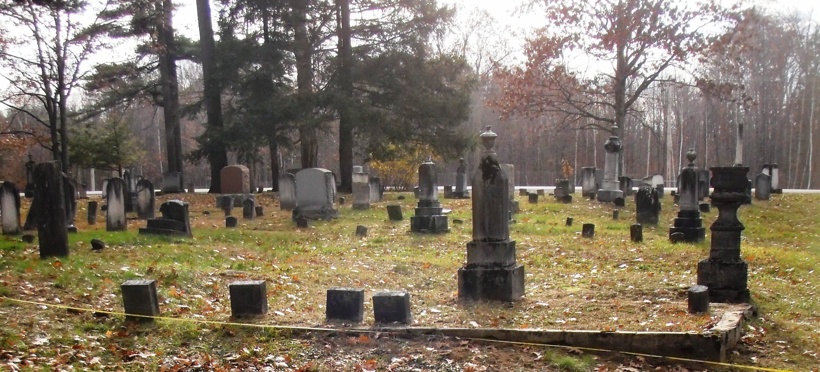
Figure 1: Sheepfold cemetery, looking southwest.
Most recently, Fort Drum has acquired an intern (the author), through Oak Ridge Institute for Science and Education (ORISE), to inventory and “digitize” these historic cemeteries, while applying non-invasive geophysical investigative techniques. The premise for project was conceived by E.W. Duane Quates PhD, as a means for identifying sets of attributes associated with known African-American burials, which could also be applied to suspected unmarked burials, as a means of identification.
The primary goal of this endeavor was to create a geo-referenced database. Aside from a means of ethnic identification, this database would allow for more effective resource management, and grant the public ease of access to cemetery information. This information is currently available on The Fort Drum website as searchable SharePoint listings, and being developed into a fully interactive platform by Colorado State University’s Center for Environmental Management on Military Lands (CEMML). A result of this dual-purposed database was also a large, easily manipulated, data pool which can be made available to outside researchers. The secondary goal of this endeavor was to use geophysics to investigate the possibility of unmarked burials inside of the cemeteries and outside of their boundaries. To illustrate the results of this project, results from Fort Drum’s Sheepfold Cemetery can be seen below.
Sheepfold cemetery (Figure 1) was part of the 200 acres owned by French aristocrat, James LeRay in the early 19th century. Originally this area is where he kept his sheep, his sheepfold. The cemetery contains 292 known burials (391 markers); the earliest known burial was in 1821, and the most recent burial was in 1996. As part of the (ORISE) project, the markers in Sheepfold cemetery were geo-referenced and recorded into a database. Ground penetrating radar (GPR) was also used to explore a large unmarked section of the cemetery which had been flanked by marked interments, including a known slave-turned-servant (Rachel) of the LeRay family. The results of this survey was compared against a control survey from a nearby area, which contained some of the oldest and most contemporary markers to those surrounding the open and unmarked survey area. As Figure 2 illustrates, the large, open, and unmarked area contains several anomalies which resemble the control of the smaller area in length, width, and depth, and are similarly oriented to the known interments of the cemetery (southwest to northeast).
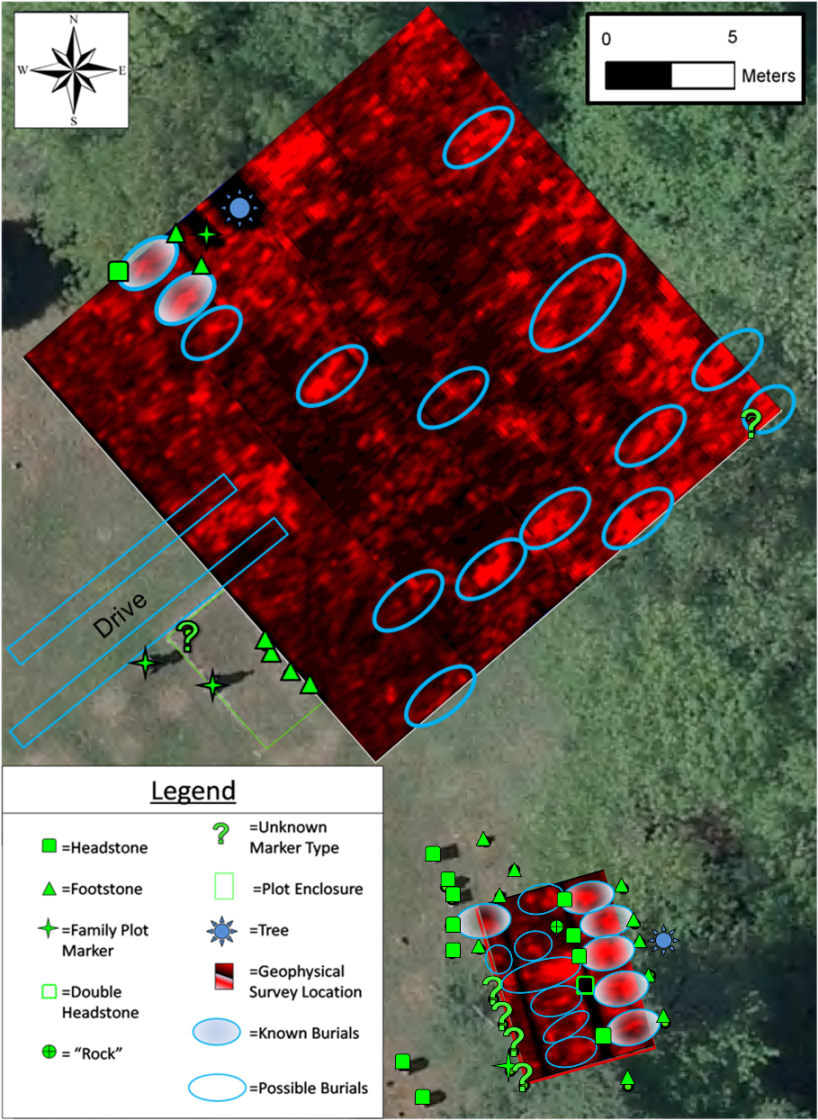
Figure 2: Sheepfold Cemetery GPR survey results. Note: 6.56 feet below the surface, 3.28 feet thick slices.
(Image courtesy of the author)
The database offers tremendous opportunities for analysis, but required preparation. To maximize database versatility, many different attributes were selected, defined, and assigned their own field. Relying partially on the University of Pennsylvania’s Historic Cemetery Plot and Marker Survey Form, over 90 different, quantifiable attributes (such as: birth year, death month, gender, age, last name, associated individuals, orientation of individual, marker type, marker height, other associated markers, grade slope, marker exposure, marker material, evident repairs, biogrowth condition, staining, cracking, foundation exposure, erosion level) were selected, with some attributes (i.e., name, death date) employed into both tables. Surveyors used multi-directional lighting and shading to decipher the wording carved on the older, and more difficult to read, markers. At least two high-resolution photos (with optimum lighting) were taken of each marker to exhibit as many design features as possible (figures 3 and 4). Each marker was also geo-referenced using high resolution aerial photography, and aided by ground measurements. The data from the field was then added to the database in two separate (but linked) tables, one for public outreach and one for resource management.
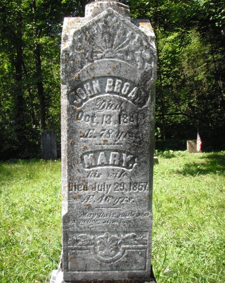
Figure 3: An example of the detail revealed by using optimum environmental lighting conditions to cast shadows into the previously invisible decorative motifs.
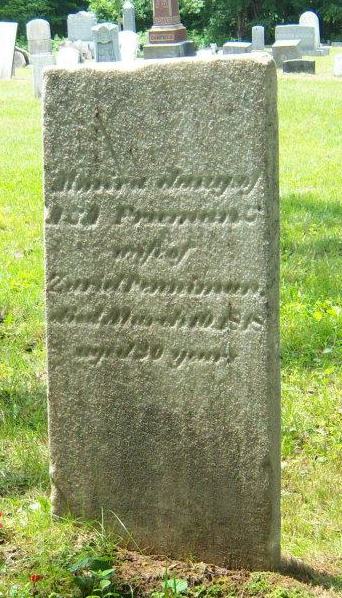
Figure 4: An example of difficult-to-decipher personal information revealed on a weathered marker, using optimum environmental lighting conditions.
Once populated, the database allows for each attribute to be referenced and cross-referenced in a nearly infinite number of ways. Figure 5 offers an example of cross-referencing individuals’ information to examine demographics. Here, average age of death is cross referenced with decade of death and with gender, displaying the average life span of each gender for each decade, as seen in Sheepfold cemetery. The database can also be used to analyze the markers themselves, via the resource management table. For instance, cross examining the different marker materials on the basis of their total condition to see which materials weather the best. In Sheepfold cemetery, ordered from best preservation to worst preservation is: zinc, granite, ferrous, marble, concrete, and limestone.
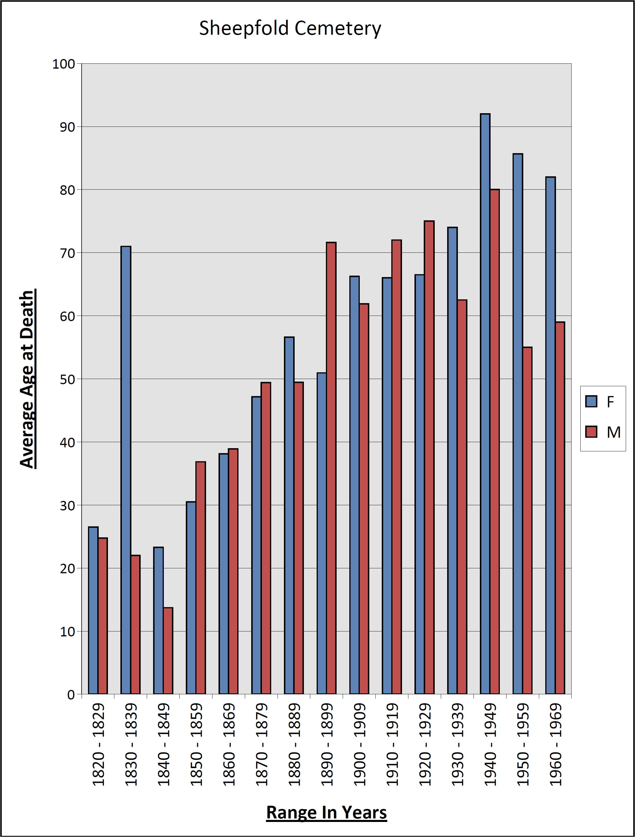
Figure 5: Sheepfold Cemetery average age of death by decade and gender. Note: does not include infants (presumed, unnamed), does include vets, each entry is represented by roughly three individuals.
(Image courtesy of the author)
When tied to the geophysical information systems, each marker or individually-related attribute in the database can also be examined in terms of its spatial meaning. For instance, each marker can now be viewed in terms of when it was placed (earliest death year), and how the individual choosing the plot viewed the other markers and the surrounding landscape. Figure 6 illustrates the result of such an analysis, in Sheepfold cemetery. The burials started in the eastern portion of the cemetery and spread out closer to the road. It also appears that after the interment of Rachel, a slave-turned- servant of the French aristocratic LeRay family (the northeastern most burial), the interments started to move away from her location more intensively and towards the southwest (until roughly a generation later).

Figure 6: Sheepfold Cemetery Interment Year Distribution (Image courtesy of Mrs. Jaime Marhevsky, Fort Drum DPW-ENV)
In conclusion, Fort Drum has utilized a variety of tools to enhance the management of and public interaction with the 13 historic cemeteries within its borders. The GPR survey offered insights into a previously speculative area, displaying similar anomaly attributes to the known burials. By properly identifying and defining marker attributes, an incredibly powerful tool has been developed for public information, resource management, and subsequent outside research. By geo-referencing the entries, the versatility of this database increases exponentially, allowing for spatial attribute comparisons and easy element location. It is important to remember that these principles may also be applied to other resources, allowing for more efficient management, public information, and data dissemination. Fort Drum’s Cultural Resource Management Program has made huge strides in its cemetery relations and management, continuing to innovate and share this sort of information through its public outreach program, which includes Facebook and Twitter accounts.
What are some applications and benefits of creating geo-referenced databases for other types of sites? (any specific examples?) At what point in the process does the dissemination of information (to the general public and possible researchers) come into play when designing and performing cultural resource management archaeology? (and why so?) What are the benefits and drawbacks of digitizing cultural resources as a means of compliance with the various historic preservation laws?
Read the other contributions for Tech Week, starting with “Understanding Cemeteries through Technical Applications: An example from Fort Drum, NY” by Duane Quates
Hands-On History
Over the last several years, Jefferson Patterson Park and Museum (JPPM) has enjoyed a productive relationship with Huntingtown High School in Calvert County, Maryland. In previous years, the school’s archaeology classes produced cell phone tours for the park, with the students working on the projects at every level, including conducting oral history interviews, developing tour themes and scripts, recording the tours and writing press releases.
")
Rockingham hunt pitcher from the privy.
This year, JPPM decided to take on a different type of project, with the newly-formed “Historical Investigations” class. The students are analyzing the contents of a mid-19th century privy from Baltimore’s Federal Reserve site (18BC27). Archaeologists excavated the site in 1980, but since the artifacts were never studied or a final report prepared, the students are working with an assemblage that has never before received any attention.
This particular privy was filled with broken plates, spittoons, chamber pots, medicine bottles, and a torpedo bottle once used to hold carbonated beverages. One spectacular find from the privy was a large Rockingham pitcher depicting a boar and stag hunt, made around 1855 by a Baltimore pottery firm.

Teacher Jeff Cunningham and a student mend a creamware chamberbpot, while another student works on a sponged cup.
The students completed cataloging the artifacts (2,200+), mended the ceramics and glass from the privy and determined minimum ceramic and glass vessel counts. Each student chose a particular artifact to research in depth, creating illustrated essays that were both posted on JPPM’s website and produced as posters for display. In addition to writing a standard archaeological report on the privy, the students also created an exhibit of their findings that are currently on display at a local public library.

Two of the students are justifiably proud of the exhibit on display at the local branch library.
It was exciting to work with students on a project that provides them with real-world experience in a supportive setting, conducting the type of analysis normally done by professional archaeologists. Even better, is watching the students get a thrill from each new artifact and the information it holds.
What types of engaged work are you doing with local high schools? Share your experiences with us in the comment section!
Help the Society for Historical Archaeology make an impact on the Hill
 Join us for a Webinar on Thursday, July 25.
Congress’ summer recess is fast approaching. What does that mean to SHA and to you? August is a great time to invite Representatives and Senators to visit local archaeological, historical and architectural sites, and to learn about the importance of cultural heritage education and preservation. It is also a chance for us to advocate for funding for SHPO offices, curation efforts and Section 106.
Please join SHA’s government affairs counsel Cultural Heritage Partners, PLLC on Thursday, July 25, at 1 pm EDT for a 30-minute webinar: “Making Our Voices Heard During August Recess.” Cultural Heritage Partners attorneys Marion Werkheiser and Eden Burgess will teach you how to reach out to local Congressional offices, prepare for visits, deliver SHA’s message, and make an impact that lasts. Join us and get empowered!
Reserve your Webinar seat now at:
https://www4.gotomeeting.com/register/750123079
| Title: | Making Our Voices Heard During August Recess |
| Date: | Thursday, July 25, 2013 |
| Time: | 1:00 PM – 2:00 PM EDT [1 hour scheduled to allow for Q&A] |
After registering, you will receive a confirmation email containing information about joining the Webinar.
Learning Public Archaeology: Experiences and Challenges from a University-Based, Long-Term Initiative
 The Fort St. Joseph Archaeological Project has been a public archaeology/community service learning program from its inception when Western Michigan University’s (WMU) anthropology department was invited to help Niles, Michigan find its “lost” eighteenth century fort. As it only enjoys one full-time, permanent faculty member, principal investigator Michael Nassaney, the success of this public component is highly dependent on the involvement of undergraduate and graduate students and community volunteers. Though grassroots in nature, it has managed to consistently offer popular public events and to expand its outreach through traditional and digital methods. Student involvement in the Project takes the form of inclusion and emersion, not just in the practice of historical archaeology, but also in the sharing of it.

Principal Investigator, Michael Nassaney conducts a lecture during the Annual Open House at the Site.
Fort St. Joseph is located within present-day Niles, MI. Occupied from 1691 to 1781 by the French then British, it served as a mission, garrison, and trading post on the frontier of the Great Lakes fur trade. The Project began in 1998 when a local history group invited WMU archaeologists to conduct a survey in search of the colonial outpost. Shovel test pits soon revealed trade goods, faunal remains, and intact architectural deposits, presenting the city and community the opportunity to reconnect with the colonial legacy in their backyard in a tangible way. For the last fifteen years, the partnership between WMU and the City has involved excavations and public education and outreach conducted by an active, engaged and ever-changing group of students and volunteers.
My involvement with the Project began in the spring of 2006 in the laboratory. Though my undergraduate degree was in Economics, I had a deep love of all that was old and a sense that archaeology had the power to tell the stories of everyday life past that were elusive in the written record. I planned to take the field school at Fort St. Joseph in the summer and was invited by Dr. Nassaney to get familiar with 18th-century material culture by helping to catalog artifacts from past seasons’ excavations. A couple hours in and I was hooked on the lab. I went on to do my master’s thesis on the topic of curation and collections management, but while I was busy studying the other three fields and finding my niche within archaeology I was also almost constantly “doing” public archaeology.

A thematic artifact display case assembled by the author.
My first field season I, along with the other field school students, learned the history and context of the Fort along with proper archaeological excavation and recording techniques ourselves and then turned around and almost immediately helped educate week-long each summer camps of middle school/high school students and adults from the community in the same. We spent the second half of the season gearing up for what has since become the annual Open House at the fort site. We educated while advertising and soliciting support for the event throughout the community. We designed t-shirts. We created content for and executed the layout of informational panels. We selected finds for and put together artifact display cases. We painted signs to direct traffic to the site. All this under the guidance of one principal investigator, the director of Niles’ Fort St. Joseph Museum, and one site veteran (and therefore public archaeology veteran) graduate student teaching assistant, who herself pulled together a group of historical reenactors to interpret the French and British periods at the fort. All field schools involve experiential learning. My first field school also happened to be a crash course in public relations, event planning and museum studies.

A field school student interacts with Open House visitors.
I served as the Fort St. Joseph Museum Intern during my first year of grad school, working on multiple initiatives to increase the public profile of the Fort St. Joseph Archaeological Project. I wrote text, chose images and oversaw the design of an informational brochure. I organized a “Meet the Archaeologist Day” at the Museum as well as a luncheon for the most involved members of the community, the goal of which was to solicit their input on future exploration and interpretation of the Fort. The next year I was a field school teaching assistant and along with fellow grad students worked to execute both the summer camps and Open House again, building upon all learned the previous year.
Over the next couple of years my peers and I represented the Project at community events throughout southwest Michigan in addition to attending professional conferences where we shared our research, and also our public archaeology experiences and learned how others were involving their local communities. My last year of grad school, I interned with the Project again, this time taking on public archaeology of an “e” nature. In the interim between my first internship and this one, web presence had surged in importance as an outreach tool, and Facebook was doing the same. The Project at this point had little to no real estate of its own on the internet. Working with WMU’s College of Arts and Sciences webmaster, I built a site for the Project on the University server and also set the Project up on Facebook. Moving beyond the brochure, I also edited the inaugural edition of the Project newsletter, the Fort St. Joseph Post.
Both undergraduate and graduate students alike have continued to maintain and expand the public archaeology offerings of the Project. In 2011 a Project blog was launched to allow field school and other students the chance to share their experiences with the Project first hand, both during the field season and the academic year. Students have also helped to produce two volumes in a booklet series, which aims to examine various aspects of Fort St. Joseph and it’s role in the larger political, economic, social, and cultural contexts of New France.

Middle and High School student summer campers are brought up to speed on ongoing excavations.
The Fort St. Joseph Archaeological Project offers undergraduate and graduate students a unique opportunity to dive headfirst not just into archaeology, but public archaeology, learning how to while doing and serving the community at the same time. As with any sort of grassroots initiative, there is need for and therefore the ability to accommodate different interests and talents. And as I can personally attest, this chance to be a jill-of-all-trades can lead one to learn skills that have a great deal of value in the real under-funded/tight-budget world. But being on the student side of this equation, I didn’t experience the one obvious downside of a university-based initiative, namely the revolving door. Students come, put in their time, and go, which makes it somewhat difficult for those in charge to maintain at a consistent level the features that the community comes to expect . WMU offers a terminal master’s degree in anthropology, which makes the problem even more acute. Perhaps this is where the community itself must step up their involvement. What challenges have others encountered and how have they been overcome?
I was fortunate to have the Fort St. Joseph Archaeological Project be my first foray into archaeology. I learned a ton, I was given a lot of responsibility; in turn I felt valued and which pushed me to take initiatives and to do my best to excel at all of the opportunities I was offered. I know not everyone has such chances in their pre-careers. Current and former students involved in public archaeology initiatives, in what ways were you “allowed” to contribute as a student? How has your experience as a student of public archaeology informed your archaeology practice?
For more on the Fort St. Joseph Archaeological Project visit our Website, read our Blog, and check us out on Facebook!
Webinars: A New Frontier in Archaeological Training
 The SHA’s Academic and Professional Training Committee (APTC), working with the Conference Committee, offers a range of training and professional development opportunities at the annual conference. We have workshops, roundtables, and fora covering many topics, most developed in response to member interest and needs. To augment these, the APTC plans to try year-round training (not during the conference). You have the opportunity to be part of this on July 17.
This past winter, members of the APTC started kicking around the idea of putting together a set of webinars to offer training and instructional opportunities for the SHA during the year between the conferences. These would supplement the annual conference workshops, which will remain unchanged.

Webinars (a portmanteau of “web” and “seminars”) are on-line sessions where attendees can interact (audio at least, also video if people have cameras in their computers) and, depending on the software involved, view the moderator’s desktop together. Webinars are increasingly common in business and other fields, and they allow people scattered across the globe to meet to discuss business, undergo training, or just catch up, all at minimal cost.
The APTC would like to see members of the SHA interested in hosting or attending such web-based training sessions step forward with ideas for webinars. These could range from technical material like database management, curation techniques, or remote sensing applications to theoretical, topical, or regional topics. Professional development topics such as job hunting or transforming your dissertation into a book (thanks, Myriam Arcangeli [@Terrailles]) would also work. The field is very wide open.
Some Things to Consider
One of the benefits of this medium is the low cost. In its initial stages, we would run the webinars through systems such as Google Hangout (with up to 10 seats) or Blackboard Collaborate (for more). With no room to rent, no travel to subsidize, and only the host’s fees (if there are any) to defray, we envision these to be among the most cost-effective development tools available.
There are, of course, a few obstacles. Depending on your preferred method of content delivery (audio only, audio and video, chat), you place different data and computing demands on participants. If an attendee is on a dial-up connection, they may not be able to stream video. Also, some of the webinar delivery systems require downloaded content that, while not usually excessively resource-hungry, may require some lead time for users to get approved and installed (I’m looking at you, Department of Defense archaeologists).
Webinars and the Student Member
As webinars let people log in from wherever they can get internet coverage, they do not require the travel funding that can be a big impediment to attendance. This is particularly true for college students. We are particularly interested to get feedback from students about what kinds of webinars they would be interested in attending.
The scheduling flexibilities of webinars will allow us to focus on applying for graduate schools, preparing for conferences, and other topics that would be more useful earlier in the year than the conference allows. The APTC will be working with the Student Subcommittee of the APTC to develop student-oriented opportunities.
Getting the Ball Rolling
If you have an idea about a topic, you can e-mail me at cdrexler@uark.edu, tweet me (@cgdrexler), or stick an idea in the comments section.
If you’d like to host a webinar at some point in the future, send me a note and I’ll get you an invite to our first webinar on July 17, from 2-3 pm (Eastern). This inaugural webinar will focus on… webinars! We’ll focus on topic ideas, get some background on content development, and discuss the use of the technology. Drop me a line if you want to participate!
Acknowledgements
Amber Graft-Weiss and Terry Brock contributed to a lively Twitter discussion on this topic that helped develop and refine where we would like the webinars to focus. Shelley Keith, of Southern Arkansas University, advised on materials related to webinar content development.
Pingback: WAC May 2012 eNewsletter – Volume 40 – World Archaeology Congress