
By Steven J. Filoromo, RPA, TerraXplorations, Inc., Baton Rouge, Louisiana
Bayous are subject to constant change over the long course of history. The rate of change today is unprecedented. As a result, many archaeologists working in southern Louisiana are developing unique approaches to understand the changing environments and their heritage at risk.
Mentions of Louisiana’s swamps and bayous conjure images of a shifting landscape of wild or bucolic imagery. These images often include scenery where Spanish moss hangs over still water while cypress knees chart clear paths for flat boats to cross. One could imagine the diversity of bird calls filling the air while a sea of lush green forests directs one’s path through a seemingly thick and remote wood.
Set back from the Mississippi River’s modern levee system, agricultural fields become a sea of sugarcane set ahead of a thick backdrop of swamps and bayous. Nevertheless, this seemingly remote landscape is a significant cultural resource. While difficult to navigate now, these waterways provided the same pathways where enslaved individuals formed networks towards freedom during times of antebellum oppression, and others including, but not limited to: Isleños, Acadians, and the ancestors to modern Chitimacha, Coushatta, and Houma (to name a few) who used these waterways to transport items and ideas. Archaeologically speaking, probability modeling relies upon data that, not to the researcher’s fault, may not consider historical environments, land use, and other environmental data that may not necessarily appear within historic cartographic sources. The core issue with researching settlements in these environments is that archaeologists could assume relative stability over time. The course of the bayou is not static. In the face of a changing climate suffering from significant losses to land and heritage, we are left with opportunities to develop creative ways to identify this heritage at risk. One such methodology we can employ is shallow geophysical surveying.
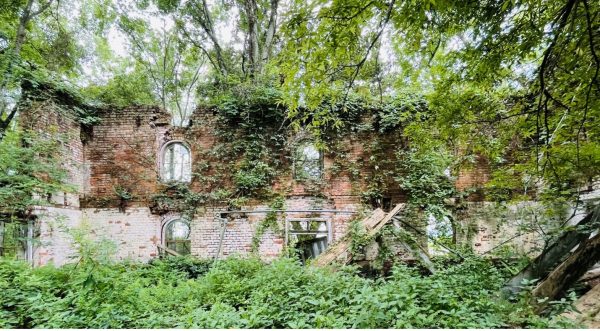
Figure 1. Sugarhouse ruins in the backswamp, Ascension Parish. Photograph by Steven Filoromo, July 2022.
Within southern Louisiana, my colleagues and I are fortunate to have had opportunities to employ magnetometry across various sites. Magnetometry is a unique form of shallow geophysical surveying. The data in total across a site or landscape create a palimpsest of natural and cultural features, condensing approximately two meters of stratigraphy within an atemporal two-dimensional image. Things like relict streams, landscape modifications, hearths, architecture, and more can appear. While those distinct cultural features are generally the target of archaeological research, locations of relict landforms such as ancient bayous or relict streams (coulees in Acadiana) are also critical to understanding changes in the landscape. The appearance of these features within magnetic data depends on mixed variables. In a basic sense, the magnetic gradient of sediment layers ranges depending on their residual (remanent) magnetization from the acquisition from an external field and their ability to be magnetized from an applied field (magnetic susceptibility). These differences in the gradient are significant as relict channels have different remanent magnetization, thus appearing in contrast to the surrounding environmental and cultural features (e.g., Stele et al. 2020; Heller & Evans 2002).
During recent archaeological projects in Iberville Parish, where we were determining the integrity of a sugarhouse site (Phase II testing) and a full-scale excavation of a large Coles Creek village (Phase III data recovery), we conducted a magnetometry survey before any new ground disturbance. We covered approximately 3.3 acres for the sugarhouse, and at the Coles Creek period village, we surveyed 7.33 acres. Fortunately, both sites sit within a similar location set back from the levee, along with the exact change in elevation within the adjacent sugarcane fields. For the sugarhouse, there were very few indications of any distinct cultural features; whereas, at the village, there were numerous anomalies related to structures, a historic road, and several ditches. Notable between both datasets were subtle contrasts in low magnitude (between 2 and -2 nT, or nanoTeslas) magnetic variations across both areas. The general trend between both locations was that an area of low magnitude negative magnetic variation defined the boundary between the fields and bayous. The difference between the two locations was that the interior of the former bayou at the village contained more prominent, subtle anomalies with positive magnetic variation.
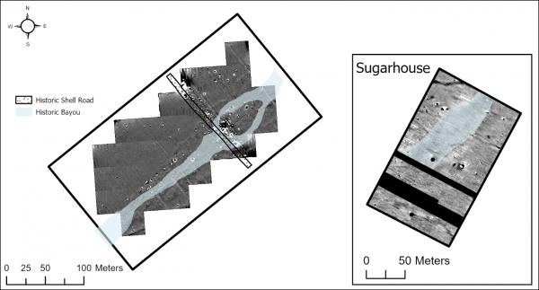
- Figure 2. Magnetometry data at the village and sugarhouse.
- During the excavation of the sugarhouse, a series of mechanically excavated trenches generally confirmed the location of the former bayou channel. Soil textures and colors were noticeably different, whereas bayou soils have more clay and darker colors. We observed a similar trend in the village. Given the size and nature of investigations, we could delineate the bayou as it crosscut the village fully. The areas of more positive magnetism within the bayou comprised significant quantities of terminal Coles Creek (ca. AD 1200) ceramics. Given the nature of fired ceramic production and the quantities of these materials, the areas of higher magnetism within the bayou are unsurprising. During the excavation of the village, it became clear the significance of this waterway to the layout of the village. Massive pits and several hearths marked the center of a distinct shared communal area with sheet middens surrounding several smaller neighborhoods focused on the sides of the former bayou.
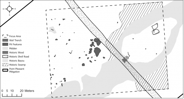
Figure 3. Portion of excavation results in a focused area at the village.
While the location of the bayou next to the village provides insight into the use of the area before attempts of French colonization, the bayou was a persistent landform even through the early 1800s. A historic shell road and cypress bridge were in more shallow deposits at the Coles Creek period village. To effectively interpret the timing of these features, we drew from extensive land ownership history—maps from the Mississippi River Commission in the late 1800s provided a baseline for determining more historic placements of drainage systems at the site. Sifting through the family’s letters, more general correspondence discussing the acquisition of backswamp lands helped place these features in both time and place. In 1850, the U.S. Government passed the Swamp Lands Act, which enabled the purchase of backswamp lands (as determined by the Secretary of the Interior) for drainage and agricultural production. Thus, the landowner could purchase the land behind his property and turn new fields over as enslaved laborers cut fresh cypress and hardwoods for property improvements and fuelwood for the sugarhouse. As such, the bayou was likely still active until the 1850s.
As a result of tracing this bayou between several sites within adjacent sugarcane fields, we began to alter our approaches to surveying these areas. Where some once might have advocated for greater spacing between shovel testing approaches on a traditional archaeological survey, we have located additional earlier pre-Contact and Colonial European sites. Development across these areas and the greater birds-eye view of the long-term impacts of erosion and environmental change add additional layers for identifying and protecting heritage at risk. The constant fluctuation in these dynamic environments provides one perspective on how we attempt to better understand the history of land in these environments.