Allyson Ropp
Historic Preservation Archaeological Specialist, NC Office of State Archaeology
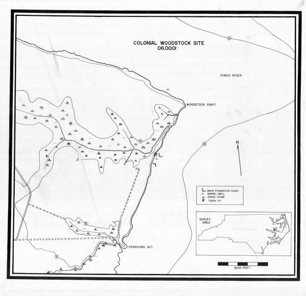
Take a second to imagine the colony of North Carolina in 1738 and being in a small town on the Pungo River in North Carolina. This town, called Woodstock, was a small port town off the Pamlico River and served as the county seat of Hyde County. Woodstock was a world unto itself in the swampy landscape of the North Carolina Coastal Plain, with a courthouse, plantations, and wharves bustling with ships and sailors. Where is this town today, as it is probably one you have never heard of?
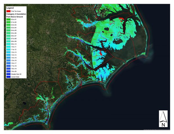
Woodstock is now buried beneath sediment and water in the Pungo River. It exists only as an archaeological site that has already been subsumed by rising sea level, exposed to coastal erosion, and impacted by hurricanes. It is one of over 5,500 archaeological resources in the thirty-one counties of the North Carolina Coastal Plain that are threatened by rising seas, erosion, intensified storms, and associated storm surge.
The North Carolina Office of State Archaeology (OSA) is tasked with preserving archaeological resources throughout the state, including the over 5,500 at risk in the Coastal Plain. The OSA works to assess and manage the current and future impacts of these environmental threats to archaeological resources. Much work has gone in surveying large swaths of the coastal counties to create an inventory of resources. These surveys documented terrestrial, submerged, and intertidal sites throughout the Coastal Plain. This baseline of information allows managers to grasp the extent of sites in that region of the state.
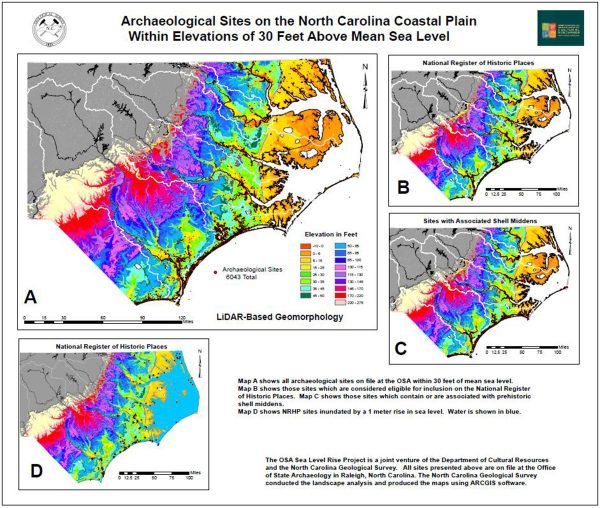
Since the early 2000s, there have been efforts to understand the types and quantities of sites at risk from sea level rise. This work was refocused with the release of the 4th Assessment Report by the Intergovernmental Panel on Climate Change, which estimated sea level would rise between 0.5 and 2 meters by 2100 (IPCC 2007). In the wake of this assessment, OSA, under the guidance of Lawrence Abbott, undertook the OSA Sea Level Rise Project to provide a baseline estimate of the number of resources to be impacted under the IPCC sea level rise estimate. Abbott assembled data for archaeological resources within 30 feet of the mean sea level across 31 counties in the Coastal Plain. Within this data, he examined their evaluation for the National Register of Historic Places. Only 204 of the 5,700 sites within the project confines had been assessed and deemed eligible, approximately 2,400 were deemed ineligible, and the rest were not evaluated (Abbott 2011). All are at risk.
Now let’s fast forward to the hurricane season of 2018…
Throughout the Atlantic that season, 15 storms were named, 11 of which grew to hurricane strength, and 4 of which made landfall. Two of these named hurricanes directly impacted North Carolina. In early September 2018, Hurricane Florence made landfall near Wrightsville Beach as a Category 1 hurricane. It brought extensive storm surge and considerable rainfall, causing wide-ranging flooding across the southeastern portion of the state and over $22 billion in damages. About a month later, Hurricane Michael struck the Florida Panhandle as a Category 5. It quickly downgraded and moved north, reaching North Carolina the day after making landfall. With it came a deluge of rain to the western and central parts of the state, causing approximately $1 billion in damages in North Carolina alone.
The hurricanes impacted many aspects of life in North Carolina and in surrounding states, from infrastructure to homes to agriculture to people themselves. They also impacted archaeological resources and historic structures. In response to these storms and Typhoon Yutu, the National Park Service issued $47 million in emergency supplemental funding for cultural resource protection and preservation in states and territories impacted by Hurricanes Florence and Michael and Typhoon Yutu. This funding is aimed to finance brick and mortar projects for the restoration and stabilization of historic structures and survey projects to identify and assess impact resources to assist with future storm mitigation.
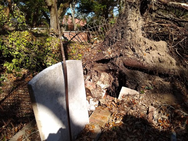
North Carolina was awarded $17 million of this supplemental fund. For North Carolina, this award is funding 27 projects across counties with FEMA declarations related to the 2018 storms. Two OSA projects are being funded from this award. One of the projects is the Historic Cemetery Survey Project, headed by OSA’s Historic Cemetery Specialist Melissa Timo. This project will assess the condition of historic cemeteries on state lands in nine coastal counties. In addition to assessing the conditions of historical cemeteries, the Cemetery Survey will locate and record cemeteries not documented in the North Carolina Site File and identify discrepancies in the Site File. Since they are underrepresented in state records, a major goal of the Cemetery Survey is to illuminate the histories of African Americans communities and associated unmarked burial grounds and cemeteries. The results of this work will be used to develop site condition monitoring and storm preparedness plans in coordination with the land-managing entities stewarding these places.
The sister project to the Historic Cemetery Survey is the NC Shorescape Survey Project, designed by Assistant State Archaeologist Mary Beth Fitts and Chris Southerly, Deputy State Archaeologist – Underwater. While the Historic Cemetery Survey focuses on historic cemeteries, the Shorescape Survey focuses on archaeological resources in state lands and waters along the shorelines of twelve coastal counties. Employing a thematic approach, this project will combine terrestrial and underwater survey methods to identify underrepresented resource types and create information for stewardship plans, historic contexts, and public education. Of the thematic contexts proposed for study, so far planning efforts have focused on maritime industries and the African American experience in Coastal North Carolina. However, it is expected that a whole range of sites associated with different periods of North Carolina’s history will be recorded 60 meters inland of mean sea level, and 60 meters seaward. .
The focus of work so far has been on conducting a review of existing archaeological site and cemetery data and prioritizing areas for archaeological investigation. I’ve gathered historical records and maps relating to maritime industries, cemeteries and burial practices, and African American communities, and also conducted a geospatial analysis of the impacts of storm surge and flooding on state lands. Combining this information, I mapped areas with storm impacts, previously documented archaeological sites, and locations with high potential for unrecorded historic sites to identify areas of high interest, medium interest, and low interest in anticipation for beginning the surveys.
So what’s next for heritage at risk in Coastal North Carolina??
Well, it isn’t all bleak! These two survey projects are moving forward. The results of these projects will help OSA understand the impacts of storms on archaeological resources and implement management strategies to preserve these resources as best we can. A follow-up study to Abbott’s Sea Level Rise project is also underway in light of the most recent IPCC study and the documentation of more archaeological resources since 2011.
To learn more about our project, follow OSA on Facebook (North Carolina Office of State Archaeology), on Twitter (@ncarchaeology), on our blog (All Blogs | NC DNCR Office of State Archaeology (ncdcr.gov))., and tune into the Submerged NC Webinar series (Submerged NC Webinar Series | Monitor National Marine Sanctuary (noaa.gov).
Citations
Abbott, Lawrence E, Jr.
2011 The Office of State Archaeology Sea Level Rise Project: Initial Results and Recommendations Concerning the Adaptation of Cultural Resources to Climate Change. White Paper. Presented to the Department of Cultural Resources Regarding the Potential Effects of Sea Level Rise on Archaeological Sites in the Coastal Plain of North Carolina. Office of State Archaeology, Raleigh, NC.
Intergovernmental Panel on Climate Change (IPCC)
2007 Climate Change 2007: The Physical Science Basis. Contribution of Working Group 1 to the Fourth Assessment. Report of the Intergovernmental Panel on Climate Change, S. Soloman, D. Manning, Z. Chen, M. Marquis, K. B. Averyt, M. Tignor, and H. L. Miller (editors). Cambridge University Press, Cambridge.