
Christopher N. Matthews, Alexis Alemy, and Sophia Hudzik
During the Spring 2016 semester, Montclair State University Professor Christopher N. Matthews worked with undergraduate students Alexis Alemy and Sophia Hudzik together to create an online, interactive document that tells the story of the Native and African American community of Setauket, New York, a community that has been the focus of a historical and archaeological study since 2009.[1] Click the link above to view the full document.
This document illustrates some of the results of this study on the ArcGIS ‘Story Map’ platform created by ESRI: https://storymaps.arcgis.com/en/. As our project is driven to address a significant problem in the way local history is told in Setauket, we call our story map ‘A Counter-Map of Setauket, New York.’ In the following we explain a little more about the theory of counter mapping, describe the local context, and detail what was involved in creating our map. Story maps can be of vital use to archaeologists and other researchers by providing a low cost, relatively easy way to make scholarship available to the public in an accessible and exciting online format.
What is a Counter-Map?
In Rethinking the Power of Maps, Dennis Wood explains that a counter-map is a reality presented as a “counter” to that which has already been constructed through supposedly “factual” mainstream stories and maps. He explains that we unconsciously rely on maps to provide a set of unquestioned facts about the spatial world. He reminds us, however, that even the highest quality maps are carefully constructed versions of reality that represent the interests and perspectives of those who are empowered to create maps.
Maps highlight and draw our attention to what mapmakers want us to see and thus push other aspects of our spatial realities to the background or erase them altogether, and, oftentimes, it is marginal people and communities that are left out. Counter-mapping is an ideal strategy for presenting alternative narratives of the past because it literally places communities that have been neglected back on the map. Moreover, because we see and experience so much of our world through the lens of maps, we think this is an incredibly effective way to transform the dominant historical narratives by revealing the physical presence of minority groups erased by traditional maps.
Why a Counter-Map of is Setauket?
A good example of the influence that maps have over the way we perceive reality can be found in Setauket, NY. Here the Native and African American community fights to be recognized for their contribution to the historical record, despite the fact that Setauket cultivates an identity as a historic town dating to the colonial era. In fact, histories of Setauket are flush with mainstream narratives about the Revolutionary-era Culper Spy Ring (the story behind the AMC series Turn), the 19th century paintings of William Sidney Mount, and a 20th century historic preservation effort that has fostered a bucolic and increasingly white upper-middle class suburban village. In other words, white leaders in Setauket have emphasized a certain version of American history that privileges Revolutionary heroes, prominent white artists, and an elite heritage. Missing from this history are the lives and contributions of Setauket’s minority community, which predated the arrival of the first European colonists and continues through the present day.
While this may be an accidental omission by those with a preference for patriotic American stories, it has created dire consequences for the nonwhite community. Historically restricted to laboring and domestic work, people of color did not accumulate the wealth now required to afford to live in “historic” Setauket. As such, many have left their ancestral home and others are being forced out by extraordinarily high costs of living. Since the predominantly Native and African American neighborhood was not included in any of Setauket’s three historic districts, houses there were not protected by any preservation statutes. As Setauket gentrified in the late 20th and early 21st centuries, developers have bought out these homes, razed them, and built expensive, out-of scale structures in their place. Erased from historical memory and excluded from the historic preservation measures that protect other old sites in town, Setauket’s minority community shrinks with each passing year.
After a recognized historic house was demolished in the neighborhood in 2005, the minority community fought to establish the Bethel-Christian Avenue-Laurel Hill Historic District. This new designation recognized the long history and contributions of Native and African Americans to Setauket and offered a measure of protection to homes in their neighborhood. Seeking to strengthen the narrative of their past and to help to secure their future in the village, the community invited archaeologists and historians to dig deeper into the historical and material record. Results of this research are the focus of the counter-map we created.
How to make a counter-map?
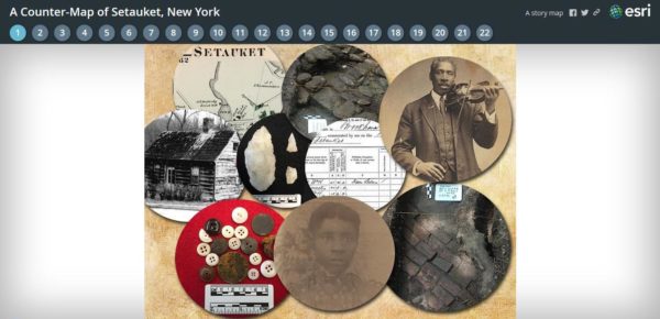
A counter-map is a map with a purpose. The Counter-Map of Setauket, New York is structured as a ‘story map’, meaning that it tells the story of a specific community created through collaboration between scholars, students, and descendants. Our story map is a collection of the Native and African American community’s memories and memorabilia culminating in a visual and written experience designed to not only recount this story, but to place it physically on the map of Setauket.
We began with a list of sites and stories, collected through interviews, excavations, and historical documentation. We then decided which of these places would be the most effective story tellers in our map. Each site is a page in the story map. These pages describe the sites and explain their significance, reveal their locations, and include pertinent and compelling images. The historical data came from research done by community members, team researchers, and students of Montclair State and Hofstra Universities.
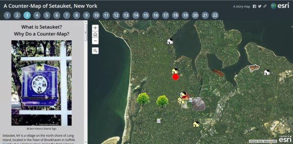
Next, we uploaded a spreadsheet of coordinates and other information about the sites onto the ArcGIS Story Map site. The coordinates are then embedded in a Google Earth map. Each site showed up initially as a pin point, which we customized with our own designs. We chose to highlight, for example, whether a site had been excavated or whether a structure was still standing. These attributes enrich the story of both the preservation and neglect of Setauket’s Native and African American community heritage.
Story maps are especially effective because they include images, and we used a lot! We housed each picture on a Flikr account because the story map platform does not store the images, but imports them to the map with a url. Images illustrate our sites, stories, and the base map we composed on ArcGIS. To pull the reader further into the story we also used other methods for visuals including interactive platforms like Juxtapose and Google Street View.
Once complete the story map arranges lots of small pieces and stories in a coherent, interactive frame. Together they create a new and larger story that challenges the dominant historical narrative of Setauket and establishes the long presence of the Native and African American community across Setauket’s landscape.
[1] This effort is led by a collaborative team known as ‘A Long Time Coming’ (ALTC), who have been supported by descendant community members, researchers, and students associated with Higher Ground Intercultural and Heritage Association, Inc., Montclair State University, Hofstra University, and Education Works. ALTC principals are Robert Lewis (Higher Ground), Chris Matthews (MSU), and Judith Burgess (Education Works).